How We Got Here
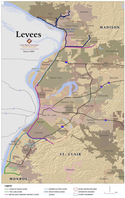
In August 2007, the Federal Emergency Management Agency (FEMA) announced its conclusion that the levees protecting a large area in Southwestern Illinois from flooding no longer meet the agency’s requirements. The result of FEMA’s conclusion is to change Southwestern Illinois’ flood insurance designation as part of its national Flood Map modernization process. FEMA’s actions would classify much of St. Louis’ Metro East as subject to flooding as if the levee system did not exist at all. This conclusion was based on a finding by the U.S. Army Corps of Engineers (USACE) that the agency had “reduced confidence” that the 74-mile levee system could protect against a flood that has a 1% chance of being equaled or exceeded in any single year (commonly referred to as a 100-year flood or a base flood) without the need for flood fighting. As a result, the American Bottom, an area of 174 square miles in Southwestern Illinois that is home to 156,000 people, 4,000 businesses and 56,000 jobs in 25 communities in Madison, St. Clair and Monroe counties, would be declared a Special Flood Hazard Area (SFHA), with dire consequences for our region’s economy. While we continue to dispute FEMA’s conclusion, we must take immediate steps to demonstrate that we can meet FEMA’s standards for flood protection.
Widespread Impact
FEMA’s announced decision to deaccredit the levee systems protecting the American Bottom, which is the industrial core of the St. Louis region, will have a dramatic and chilling effect on economic growth. Most homeowners and business owners would be required to buy flood insurance at substantially increased rates, which may not be affordable for many. For homeowners who cannot afford insurance, the result could be foreclosure. Estimates prepared for the FPD Council indicate that flood insurance premiums could conservatively amount to $50 million annually. In addition, any new structure built within what would be deemed as a Special Flood Hazard Area would be subject to new building standards, including elevation requirements and construction limits, adding significant cost and likely deterring future development in our region.
Defining the Problem
While the levee systems were built by the USACE generally in the 1940s using design standards in place at the time that exceed 500-year protection, the USACE now believes that the design was deficient as measured relative to current engineering standards. Consequently, the issue here is not a failure of adequate maintenance, or any dramatic change in the condition of the levees, but primarily a change in engineering standards and in the procedures for measuring risk.
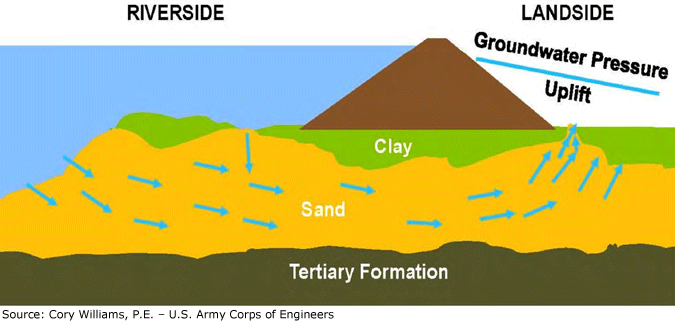
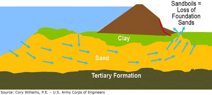
Based on deficiencies primarily related to seepage coming under the levees during high water events and the advanced age of some related facilities, the levees may not provide adequate protection against a 100-year flood without supplemental flood-fighting measures, and under FEMA’s standards, can’t be certified. They reached this conclusion despite the fact that these same levee systems have consistently passed thorough annual inspections by the USACE.
Since FEMA’s announcement, local officials and the FPD Council have repeatedly requested data, analysis, and studies from FEMA and from the USACE to determine whether the decision was justified, but responses from both agencies suggest that the decision made in 2007 to deaccredit the area’s levee system was not based on published data or analysis by either agency and that the process required by law to remap the area was not followed.
Compounding the challenge for our region is the fact that even though the levees were designed and built by the federal government, the responsibility for capital improvements largely falls to local authorities because of the enormous cost and extended time it would take for the federal government to do the job. If it was up to the federal government and the USACE to improve the levees, the cost would potentially be $500 million or more, and the schedule would be forty years or more.
Underseepage – Formation of Sand Boils

Underseepage » Instability

Local Leaders Step Up
Local leaders have recognized the urgency of this situation and, with little or no assistance from federal agencies, have been working methodically to have the Metro East levees improved to the latest federal standards. They have secured the funding for levee improvements in the form of the ¼ percent sales tax, established the FPD Council to oversee the work and continue to work closely with the FPD Council to ensure that the improvements are made in the shortest time possible in order to dispel the cloud of uncertainty that is hanging over our region and threatening future development.
County leaders simultaneously are working with the St. Louis Metro East Levee Issues Alliance, a growing coalition of business and civic organizations, community leaders and concerned citizens focused on gaining the time needed to complete the improvements in order to prevent the devastating economic outcomes of the FEMA’s unchecked actions for the St. Louis region. They also continue to pursue legislative relief and have taken legal action against FEMA challenging the credibility and accuracy of the new flood insurance rate maps that FEMA is planning to issue in early 2012.


